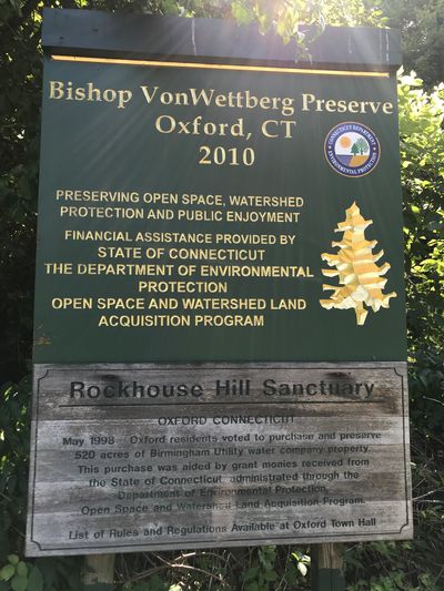
Rockhouse Hill Sanctuary
Overview
The Rockhouse Hill Sanctuary (RHS) is 600, town-owned acres of preserved, forested watershed of Four Mile Brook and the Housatonic River. The Town and the Oxford Land Trust share land-management responsibilities. Over the last 20+ years, 15 miles of trails have been developed and upgraded by the Oxford High School Youth Conservation Corps (OHS YCC), through Boy Scout Eagle projects, and by members of the Land Trust. Tens of thousands of volunteer hours have been invested and additional work has been ongoing.
Funds for trail development have been provided by the Town of Oxford, the State of Connecticut, the Valley Community Foundation, the Oxford Denzler Foundation and through private donations. Materials and work have been donated by Earthworks and the Town of Oxford.
History
Native-American artifacts have been found along the Housatonic River banks and in rock caves in the RHS. Information about their activities can be found at the Institute for American Indian Studies.
Numerous stonewalls, the age of the forest, and early land records detail the lives of early European immigrants. The land was used for farming, milling lumber, and making charcoal. Over time, these activities have subsided, allowing the land, through natural succession, to return to the natural state that exists today at the RHS.
Land ownership in the 20th century was controlled by several water companies and the Von Wettburg Family farm and nursery. During the 1990’s, Birmingham Utilities offered 520 acres for sale. The Land Trust, the Town of Oxford and various private organizations (most importantly, The Trust for Public Lands waged a multi-year, educational campaign about the importance of preserving this land as open space in perpetuity. In 1998, the voters of Oxford overwhelmingly agreed to purchase and preserve this land for $3.2 million (the State of Connecticut granted $450,000). The purchase agreement stipulated that ¾ of the area would remain passive open space, in perpetuity, and that ¼ would be available for municipal use. This latter portion became the site of Oxford High School. Adjacent to this property was the Von Wettburg Farm which the voters of Oxford purchased in the early 2000’s. Together, with adjacent Naugatuck State Forest and Keith Mitchell Forest, the entire area comprises over 1000 acres of contiguous, preserved, critical habitat for a diversity of plant and animal life.
Physical Description and Ecology
Topography: gently rolling to quite steep; elevation 50 ft to 610 ft above sea level.
Ecology: Surface – silt, clay, gravel, and boulders deposited by glacial ice melt. Bedrock –schist, gneiss, and pegmatite visible as rock outcroppings, cliffs, boulders, and small rocks.
Hydrology/Water Resources: Rockhouse Hill Sanctuary lies within the 2000-acre Four Mile Brook watershed. The above-ground areas (inland wetlands) have many valuable functions:
- Natural runoff retention basins, reducing downstream flooding during storms
- Trapping sediment from upstream areas
- Changing/improving water quality through biochemical processes
- Habitat for many plant and animal species
Vegetative Cover: upland, mixed-hardwood forest – Oaks, Maples, Hickories, Birch, Poplar, Ash, and Beech. Ground cover – Honeysuckle, Witch-hazel, Mountain Laurel, and Dogwood. Softwoods – Pine, Spruce, Fir, Larch, and Hemlock.
Invasive Species: Recently, non-native invasive plants and insects have arrived in Connecticut and have had harmful effects on the native species. In the absence of native predators, these invasives can dominate native plants resulting in an interruption of native flora and less diversity. Notable invasives at the RHS are: Japanese Barberry bush, Asiatic Bittersweet vine, Multiflora Rose, Tree of Heaven, and Japanese Knotweed. A concerted, systematic effort by the Oxford High School Youth Conservation Corps and the Land Trust has been underway to control and, eventually, eliminate the invasive species.
Wildlife: Deer, Turkey, Bear, Fisher, Fox, Squirrels, Raccoons, Skunks, Rabbits, Ringed-Neck Pheasants, Grouse, Woodpeckers, Woodcock, Beavers, Muskrat, Waterfowl, Songbirds, Amphibians and Reptiles.