Properties Owned and Maintained By the Oxford Land Trust
Katharine Matthies Woodland Preserve (45 acres)
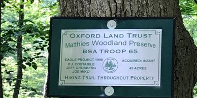
Good Hill Road, East of Old Good Hill Road.
Hiking trail throughout property.
Coordinates: N 41 24 472; W 073 10 212
Fiddlehead Preserve (43 acres)
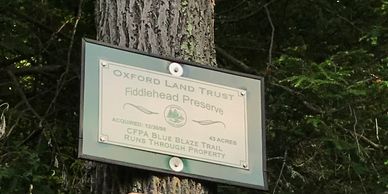
North end of Fiddlehead Road.
CFPA blue-blazed trail runs through property.
Coordinates: N 41 23 661; W 073 10 767
Walter & Katherine Dann Woodland Preserve (14.08 acres)
Walter & Katherine Dann Woodland Preserve (14.08 acres)
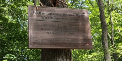
O’Neill Road, Northeast and Northwest of Eight Mile Brook.
Hiking trail along Eight Mile Brook.
Coordinates: N 41 24 472; W 073 10 212
Appetite Hill (4.1 acres)
Schiavi Wetlands (3.1 acres)
Walter & Katherine Dann Woodland Preserve (14.08 acres)

Southeast end of Wychwood Lane.
Hiking trail used to exist through property and is being re-established.
Coordinates: N 41 24 234; W 073 08 233
Chalybeate Hill (9.0 acres)
Schiavi Wetlands (3.1 acres)
Schiavi Wetlands (3.1 acres)

Located on west side of Oxford Rd. (RT 67) south of the Old Sawmill miniature golf/snack bar, across from Route Sixty Seven Professional Center. This property is named after a famous & historic spring water site on the property
Currently un-developed land with no hiking trails
Coordinates: N 41 25 535; W 073 06 537
Schiavi Wetlands (3.1 acres)
Schiavi Wetlands (3.1 acres)
Schiavi Wetlands (3.1 acres)

North side of Governor’s Hill Road between Great Oak Road and Council Drive.
Currently un-developed land with no hiking trails
Coordinates: N 41 25 156; W 073 08 156
Marion Woods (5.56 acres)

Southwest end of Walter Lane.
Currently un-developed land with no hiking trails
Coordinates: N 41 23 548; W 073 07 977
Cipusqahta (10.36 acres)

Corner of Governors Hill Rd and Randall Rd.
Hiking trails are currently being developed
Five Mile Hill - Former Sanford property (16 acres)

Landlocked behind Oxford Library.
Currently un-developed land with no hiking trails
Towantic Property (10.79 acres)
Towantic Property (10.79 acres)

East side of Hollis Drive.
Currently un-developed land with no hiking trails
Properties that the Oxford Land Trust Help Maintain
Rockhouse Hill Sanctuary

The Rockhouse Hill Sanctuary (RHS) is 600, town-owned acres of preserved, forested watershed of Four Mile Brook and the Housatonic River. The Town and the Oxford Land Trust share land-management responsibilities.
This diverse, preserved ecosystem and habitat provides an excellent educational opportunity for studying wildlife and plant life and for enjoying Nature today and into the future.
Jackson Cove Park Trails

The Pomperaug Trail connects Kettletown State Park in Southbury with Fiddlehead Trail head in Oxford. Jackson Cove Recreation Area is in the middle of this trail.